


Route Planning Example
Turn at the North Pole
|
Let's plan a trip to the North Pole as an example of the capabilities Master Navigator has. The imaginary trip is to be done with an airplane, that has some range and speed. Basically this could be any vehicle. Master Navigator will automatically show great circle paths with the distance and route tools. So planning is easy. On a ball there is no straight lines and the shortest distance between any two points is the great circle path between those points. |

Tourists at the North Pole (90N) |
Basic data about the voyage
|
Our transport vehicle is a sea plane so that in case of engine failure we are able to land on the arctic sea and maybe have some extra time to wait our rescue team. We carry of course satellite phones to make an alarm. Lake Renegade Seawolf, which can fly about 2700 km none stop at a speed of 135 kts, which is 250 km/h. |

Lake Renegade Seawolf (range 2700km) |

Kiel Airport in Germany (EDHK) |
Our voyage starts somewhere from Europe, let's say airport Kiel, Holtenau, Germany. It is situated on the north coast of Germany, near Denmark. We will later define its position accurately. Our coal is just to visit North Pole and turn back as soon as that point is reached. |
Setting up maps
|
Since North Pole is not usually clearly seen on regular maps we need new maps of the arctic region. From the WWW we find some basic maps of these regions: "Arctic Region Political" and "Europe Political". These maps show political borders and serve as our initial maps to define the route. Later when more information is available we will adjust our plan and route. |


Maps of Arctic and Europe |

Arctic and Europe with world shore line |
Here is how it looks after loading and calibrating these maps to Master Navigator. The Arctic map's projection is active showing the world as a circle. The world shore line comes with the package. It is a rather huge list of 62 thousand points. We import it and switch it on. With this list it is easy to check that the maps are correctly calibrated (created line is equal with the map's shore line). Shore line is shown dark blue on the picture. |
Measuring distances
|
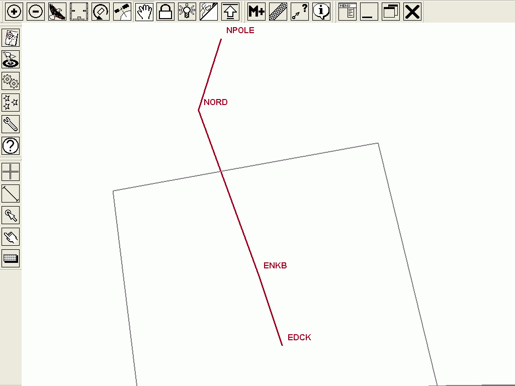
We use these maps to course tune our voyage. Positions taken from these maps at the beginning may be a bit off the point, but we will adjust that later. Using the distance tool we find out that the shortest distance from the North Pole to Kiel is 3988 km. This is too much to fly once since the plane only makes 2700 km none stop. Since we fly over the North Pole and turn back, we need some way point near the pole that is no more than 1200 km away from the pole. |

Shortest distance is 3988 km from Kiel to NP. See the red line. Measured using the distance tool. |
Finding way points from the airports list

Airports and route visible. Map background switched off. |
After switching world airports list visible, we can see that we can do one landing in Norway. Then if we do an other landing in Nord, Greenland we can fly all the trip in parts which are shorter than 2700 km. Station Nord is not listed in the standard list of airports, but that information is found in the WWW. We shall also check the location of the airport in Norway. |
|
Our final route looks very simple. And it is the shortest that can be used with our type of aircraft.
|
The route on the map. |

Map switched on. (Is there fuel available at Station Nord?) |
This is how the route looks on our general maps. We could now load it on some air maps without doing any changes, since the coordinates are valid on every map that is correctly calibrated. Points are stored in WGS84 datum. |
Checking results
|
Taking the distance listing of the route, we can see information about the way points and their distances and the total distance build up. At this point we could try to find more information about each airport and runway in the voyage and feed those maps in the system. That way we could do the landings using the computer on board. |

Our route listed and distances calculated. Bearing is true at the starting point. |
|
Flying 250 km/h we can calculate times using the distances from the list. Our final plan looks like this: Trip Bearing Dist Total Time Notice From --> To Degr N km km h ------------------------------------------- EDCK -> ENKB 353.2 980 980 4 Day 1 ENKB -> NORD 349.0 2200 3180 9 Day 2 NORD -> NPOLE 0.0 920 4101 4 Day 3 (Turn at the NPOLE) NPOLE-> NORD ... 920 5021 4 (8 hours all together) NORD -> ENKB ... 2200 7221 9 Day 4 ENKB -> EDCK ... 980 8201 4 ------------------------------------------- Total 8201 34 Min 4 days |
Collecting data about way points
|
Rest of the planning is then based on the information about times and distances. We fly first to Norway and fill our tanks and sleep over night. Then we fly 9 ours to Station Nord, fill our tanks there and sleep an other night. Third day is the day to visit the North Pole. We fly 4 hours directly to north. Since our plane is capable to fly 10 hours all together, we could spend one hour over the North Pole. But since there is probably not too much to see it could take less time. At the evening we return back to the Station Nord and sleep over night. Our fourth day we fly back to Norway and maybe the same day back to Kiel. So basically this voyage could be done in one week time. Total flight time is at least 34 hours and distance 8200 km. |
Here is a list of the way points: |

